Back to African Expeditions

Kenya 2001: Mt. Elgon National Park
The policy in the park is that visitors have to be accompanied by an armed ranger. This service was free of charge, however rangers normally got bored during long collecting hours. For the trip to caldera one either has to hike about 25 km (which is hardly possible with ill-prepared and not willing rangers), or get a car (4WD is absolute necessity; park authorities might supply one). The best place to pitch a tent to explore highlands is clearly visible end of this road (01°05’34.9”N 34°37’39.1”E, H-3500m). This locality is flat to pitch a tent, has a trail up towards peak Koitoboss, water runs nearby and nights are relatively warm (still might get below freezing point). This place is within a daily return walk to Koitoboss (4187m) or Lower Elgon (4301) peaks. Mt. Elgon has not permanent glaciations. International border goes through Lower Elgon and it is not advisable (and illegal) to cross it into Uganda.
Park HQ has generator electricity supply between sunset (about 6 p.m.) and till about 9 p.m., so light traps might be used. Forest around HQ has rather poor layer of leaf litter; it gets thicker, however, higher towards bamboo zone. Alpine zone (caledra) has characteristic Lobelia and Senecio giant plants with many beetle endemics and might be walked through without a trail. However, there is a danger in caldera of getting lost when sudden fog falls down and visibility reduces to a few meters. During my trip (small rain season) mornings were clean and sunny, when in mid-afternoon it was invariably rainy.
Warden (Director) of the Mt. Elgon N.P. is Mr. Peter Leitoro; competent and very helpful person. Mt. Elgon map by A.L. Wielochowski is recommended and might be easily found in Europe or North America bookshops (see, for example, Stanfords in London). The same author together with M. Savage produced similar map for the Mt. Kenya.
 |
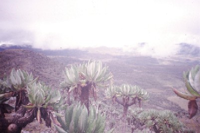
Kenya: Mt. Elgon. Giant Lobelia and some Senecio behind. H-4000m. |
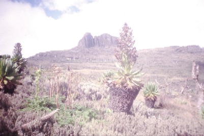 |
Kenya: Mt. Elgon. Blooming Senecio with the pik Koitobos behind. |
 |
Kenya and, mainly, Uganda: Mt. Elgon. Eastern part of hours-shoe-shaped ridge of former volcanic crater. The main depression in center of this picture is south-eastern part of the crater. Picture faces south. The higher part on the ridge on right side of the picture behind clouds is Wagagai peak (4321m), the highest point of the ridge located already in Uganda. Caldera with giant Senecio. Altitude about 4000m. |
Back to Top
Back to Vasily's main page
Back to African Expeditions
Last updated: February 03, 2002